While many ancient wonders exist only as weathered ruins—silent witnesses to lost civilizations—Dujiangyan Irrigation System is something entirely different. It is not a relic of the past, but a living, breathing masterpiece.
Built around 256 BC by the visionary engineer Li Bing, this extraordinary irrigation system continues to do exactly what it was designed to do over two millennia ago: tame the waters of the Min River, prevent catastrophic floods, and nourish vast stretches of fertile land across the Chengdu Plain.
What makes Dujiangyan truly astonishing is not just its longevity—but its philosophy. It achieves perfect water control without a single dam.
Modern engineering often seeks to conquer nature with towering concrete barriers. Dujiangyan, by contrast, embodies a radically different idea: harmony over control.
Rather than blocking the river, the system gently guides it—using the river’s own energy to regulate itself through three elegantly designed components:
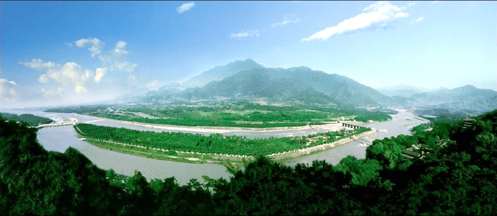
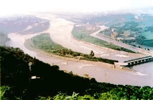
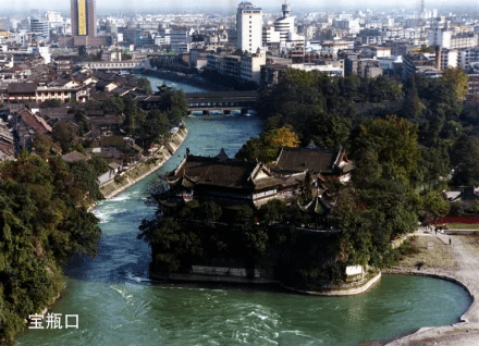
Yuzui (Fish’s Mouth Levee): A natural divider that splits the river into inner and outer channels.
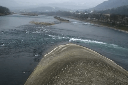
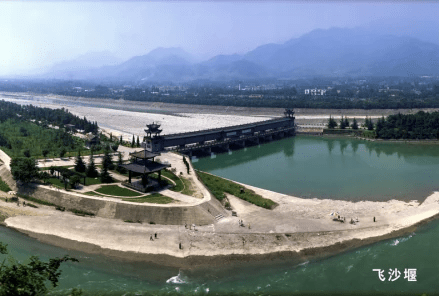
Feishayan (Flying Sands Weir): A clever spillway that uses the river’s force to flush away excess water and sediment.
Baopingkou (Precious Bottle Neck): A narrow opening carved through the mountain, acting like a natural valve to control water flow.
Fish’s Mouth Levee
Flying Sands Weir
Baopingkou
Together, these elements form a system that feels less like machinery and more like a living organism—responsive, adaptive, and enduring.
The “Four-Six” Rule: Nature’s Invisible Hand
At the heart of Dujiangyan lies one of its most brilliant innovations: the Four-Six Divide (四六分水)—a subtle yet powerful hydraulic principle.
Through careful shaping of the riverbed, Li Bing created an automatic system that adjusts itself with the seasons:
In the dry spring months, the deeper Inner River naturally draws in about 60% of the water, ensuring that farmlands receive the nourishment they need.
During the summer floods, the wider Outer River takes over, diverting roughly 60% of the surging waters away from populated areas.
No gates. No sensors. No human intervention.
Just the quiet intelligence of design aligned with nature.
The result is nothing short of extraordinary: a self-regulating system that protects against both drought and disaster.
Why It Still Thrives After 2,200 Years
It is rare—almost unimaginable—for a piece of infrastructure this ancient to remain central to modern life. Yet Dujiangyan continues to serve as the lifeline of the Chengdu Plain.
Its enduring relevance lies in principles that feel strikingly modern:
Sustainability: Instead of fighting sediment buildup, the system uses the “Flying Sands” technique to naturally flush out the majority of silt, keeping waterways clear.
Ecological Harmony: Without a massive dam or reservoir, the river remains alive—fish migrate freely, and ecosystems flourish undisturbed.
Living Tradition: The annual practice of Zhuoshui—a deep cleaning of the riverbed—continues today, blending ancient ritual with contemporary science.
Li Bing’s guiding philosophy was deceptively simple: “Deepen the channel, keep the dykes low.”
Yet within these words lies a profound truth—one that extends far beyond water management.
By respecting the natural flow rather than resisting it, he created a system that has outlasted kingdoms, revolutions, and the passage of time itself.
Recognized today as a UNESCO World Heritage Site, Dujiangyan stands as a quiet but powerful reminder:
Sometimes, the most advanced solutions are not those that overpower nature—but those that understand it.
And perhaps, in a world still learning to balance progress with sustainability, this ancient marvel is not just a story of the past—but a guide for the future.
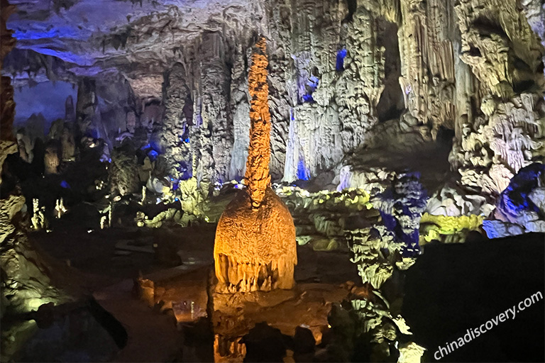
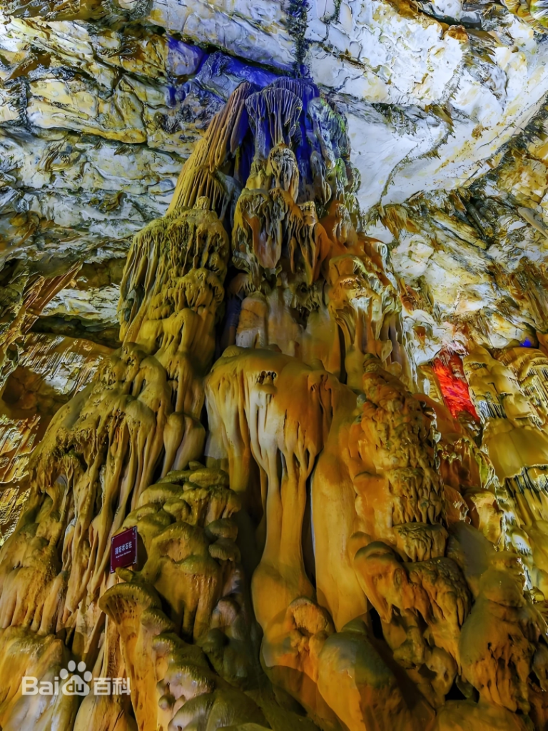
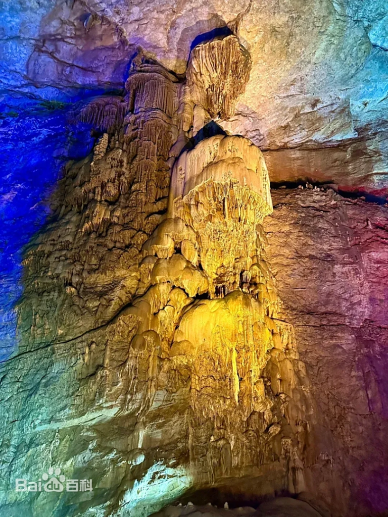
Zhijin Cave, located in Zhijin County, Bijie City, Guizhou Province, is a high-altitude dry cave of great diversity, complexity, and scale. Inside, the karst formations are unique, vast, majestic, and breathtakingly exquisite, making it a dream destination for countless visitors.
Zhijin Cave, renowned as the “King of Karst Caves,” stands out among other famous karst caves such as Zhangjiajie’s Yellow Dragon Cave (about 100,000 sqm), Chongqing’s Furong Cave (about 37,000 sqm), and Guilin’s Reed Flute Cave (about 14,900 sqm) due to its unparalleled size and grandeur. Spanning over 700,000 square meters, Zhijin Cave is the largest of its kind, featuring 12 grand halls and 47 chambers, each adorned with unique and breathtaking formations. The cave’s largest chamber reaches an impressive width of 175 meters, while six of its halls exceed 10,000 square meters in area, highlighting its monumental scale.
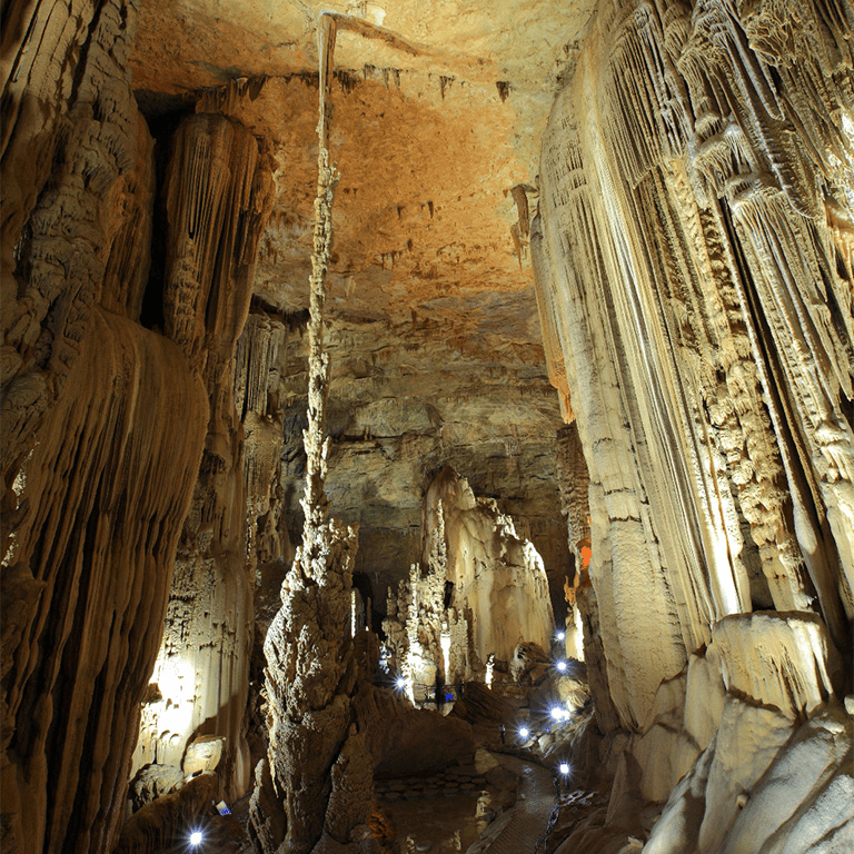
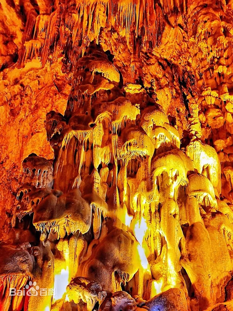
The cave is adorned with a wide variety of karst formations, including stalactites, stalagmites, stone pillars, flowstones, and stone curtains. These formations come in unique shapes, resembling pagodas, plants, animals, and even mythical creatures, showcasing nature’s artistic craftsmanship.
Among its countless highlights, several are especially unforgettable:
The Overlord’s Helmet (“Ba Wang Kui”) – A 17-meter-tall stalagmite shaped like a warrior’s helmet, known as the crown jewel of Zhijin Cave. Lit by orange light and reflected in the pool below, it appears both majestic and lifelike, as if the legendary warlord Xiang Yu himself had left his helmet behind.
The Pillar of Heaven (“Qian Ceng Bao Ta”) – At the junction of the North and South Gates stands a towering stone column that seems to prop up the sky. Called the “Mainstay of the River,” it symbolizes strength, resilience, and the ability to stand tall in times of trial.
Mother-in-law and Daughter-in-law (“Po Xi Qing Shen”) – Two pine-shaped stalagmites, one stooped like an old woman and the other upright like her filial daughter-in-law massaging her back. The scene is tender, lifelike, and moving, embodying the Chinese virtue of filial piety.
The Lingxiao Palace – A stunning stone waterfall, one of the largest yet discovered, cascading magnificently from the ceiling. Around it stand stone banners, draperies, and a majestic hall of “stalagmite soldiers,” as if a grand palace had opened its doors for a celestial council.
Snow Pressing on the Green Pine (“Xue Ya Qing Song”) – A 20-meter-tall stalagmite shaped like a pine tree blanketed in snow, one of the cave’s signature sights. Its upright strength recalls Marshal Chen Yi’s famous poem: “Though snow weighs heavily on the pine, the pine stands tall and straight.” It symbolizes resilience, dignity, and unyielding spirit.
The spectacular karst landscapes of Zhijin Cave embody grandeur, vastness, and beauty beyond imagination. A tour through its endless halls, lasting over two hours, is an ever-unfolding journey of wonder—each chamber a new astonishment, each formation a marvel of nature.
It’s no surprise that Zhijin Cave is honored as the “King of Caves.” As the saying goes: “After Huangshan, no other mountains; beyond Zhijin Cave, no other caves.” The reputation is well deserved.
Practical Tips to Visit Zhijin Cave
Zhijin Cave is located in Guanzhai Miao Ethnic Village, Zhijin County, Bijie City, Guizhou Province. The cave is approximately 120 kilometers (75 miles) from Guiyang, the capital of Guizhou Province.
Bijie City has a total of 9 railway stations and 1 airport. 2 stations are located in Zhijin County, only serving normal trains. The closest high-speed rail station to Zhijin Cave is Qianxi Railway Station, about 45 km away.
Footwear: The cave has stairs and a small section of uneven paths, and the ground can be wet and slippery. Anti-slip footwear is recommended for safety and comfort.
Clothing: The cave maintains a constant temperature of 16°C (61°F). However, the humidity and cool air can make it feel chilly, so it’s best to carry a light jacket.
Food and Drinks: There are no dining options or shops within the cave, so it’s a good idea to bring your own snacks and drinks to stay energized during your visit. If you forget to bring snacks, there is a convenience store at the cave exit where you can purchase refreshments.
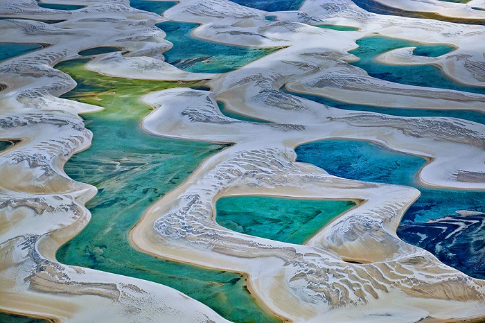
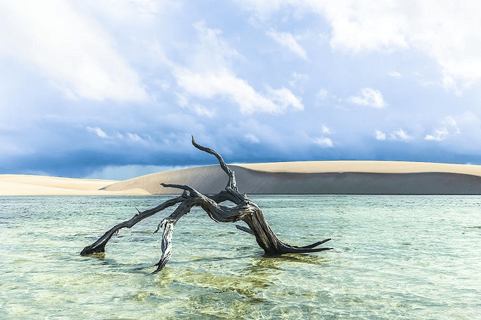
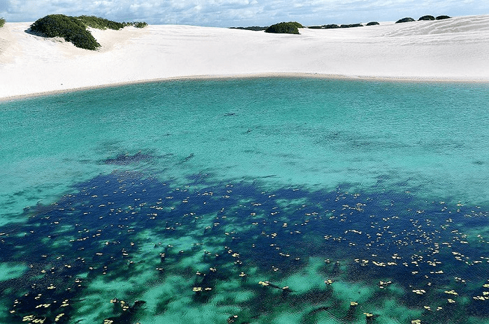
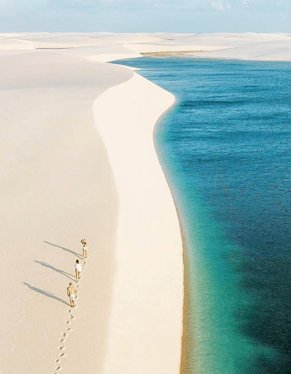
The world is vast and full of wonders—astonishing and rare phenomena that defy the imagination. One such marvel lies in Brazil: a desert with white sand dunes, turquoise and blue-green lagoons so clear you can see the bottom, filled with fish and shrimp, and set against the backdrop of breathtaking sunsets. This place seems like a paradise on Earth. It’s called Lençóis Maranhenses National Park, often hailed as “the most beautiful desert in the world.”
Unlike typical deserts, this one is dotted with thousands of lagoons formed during the rainy season, creating an extraordinary landscape of white dunes and vivid blue lakes—a natural masterpiece that amazes all who see it. You may have been lucky enough to visit, or perhaps not, and maybe you’ll never get the chance to go. But today, I’m bringing this distant beauty to you. Even if you never travel 80,000 miles around the globe, you can still enjoy the most spectacular visual experience.
A Celestial Land on Earth — The Desert of a Thousand Lakes
When people think of deserts, they often picture vast, lifeless stretches of yellow sand under a scorching sun. Water is scarce in deserts, and the sight of numerous lakes teeming with aquatic life is almost unheard of. Yet, such a magical place does exist on Earth—a place where endless deserts and crystal-clear water coexist. In this desolate land, fish and shrimp thrive. Aptly named the “Desert of a Thousand Lakes,” it is the wettest desert in the world and will completely change your perception of what a desert can be.
Located in Maranhão state in northern Brazil, just east of São José Bay and bordering the Atlantic Ocean, this desert spans 1,500 square kilometers. Despite its abundant rainfall, it has little vegetation, making it a rare desert landscape in northern South America. Scattered across the white sea of sand are countless lagoons of various sizes and colors. Fish and crabs can be seen swimming in the water, and the location is perfect for watching the sunset. Immersed in this surreal landscape, one visitor said: “So eerily beautiful, it’s breathtaking.”
How the Desert Lakes Are Formed
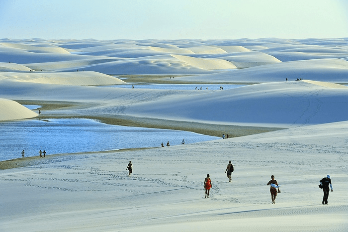
During the rainy season, valleys between dunes fill with rainwater, creating temporary lagoons that can reach depths of up to 3 meters. Every year, thousands of tourists from around the world flock here to witness this rare phenomenon. The white dunes and turquoise lagoons interlace like a massive piece of emerald from afar. Sparkling fish swim in the clear waters, while shepherds lead flocks over tall dunes and fishermen head out to sea under star-filled skies.
As the rainy season ends, the equatorial heat begins to evaporate the water. The lagoons can lose up to a meter of water per month, and during the dry season, they vanish completely, leaving only dry sand. Yet the dry season has its own unique beauty, with shimmering white waves of sand stretching to the horizon. From above, the crescent-shaped dunes resemble giant, sun-bleached linen sheets—hence the name “Lençóis Maranhenses,” meaning “sheets of Maranhão” in Portuguese.
This unique landscape is the result of geography and weather. With an annual rainfall of 1,600 mm—300 times more than the Sahara—rainwater is trapped beneath the sand by an impermeable rock layer, forming lagoons in shades of blue, green, and black. Nearby rivers carry heavy sediment, which is deposited at their mouths. In the dry season, strong coastal winds blow the dry sand inland, gradually creating this desert over time.
Situated along Brazil’s northeastern coast, Lençóis Maranhenses benefits from the country’s high rainfall, thanks to the world’s largest tropical rainforest. This abundance of water gives rise to the unique scenery that makes it the most beautiful desert on Earth.
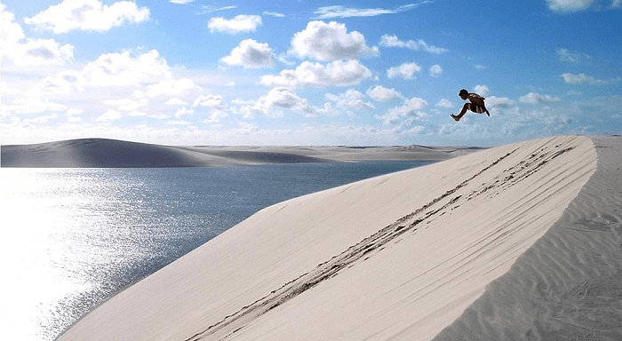
Originally called Lençóis Maranhenses, the desert is now more popularly known as the “Desert of a Thousand Lakes” and has been designated as a national park. Covering over 1,500 square kilometers, it stretches 50 kilometers inland from the dunes to the beach. The landscape is so striking that it captivates every visitor. In this place, where you would expect lifeless sand, there is water, fish, and thriving life. It’s a dream for photographers—every snapshot is like a cinematic masterpiece. You can hike with a backpack, camp, and swim in the lake that catches your eye. As the sun sets, the colorful clouds create a scene of pure magic.
A popular way to explore is by helicopter, which offers a 35-minute aerial tour across the desert. However, this misses the chance for a close-up experience. The best way is still to go in person.
From the state capital São Luís, it takes about 5 hours by car to reach Barreirinhas, the town closest to the desert. There are four daily bus services despite the high number of tourists. Barreirinhas is the main gateway into the heart of the desert.
We chose to enter the desert by water and exit by land. Riding a speedboat, we stopped at various scenic spots along the way. At a small town dock, we sampled a local fruit wine made from simply fermented mixed fruits—refreshing and unique, only $2 per glass.
At the desert’s edge, mangroves thrive, home to crabs, clams, and birds. The white sand dunes and blue lagoons make this place seem like paradise. It’s perhaps the world’s most surreal desert—where extremes meet: desert and lake, dry and wet. From afar, the landscape looks like a massive jade in white and green.
Nature’s Secrets of the Desert
From January to June, heavy rainstorms occur almost daily. Instead of soaking into the sand, the rainwater collects in valleys between the dunes. These clear, sky-colored lagoons can appear bright blue, turquoise, or even golden at sunset. Teeming with fish and shrimp, people come here to fish, swim, or just enjoy the view.
Vegetation is sparse, as the sand has buried most of it over millennia. Under intense sun, surface temperatures can reach 80°C. The local name “Lençóis Maranhenses” captures the look of the dunes—like stretched, sun-dried linen sheets.
A Paradise of Adventure and Beauty
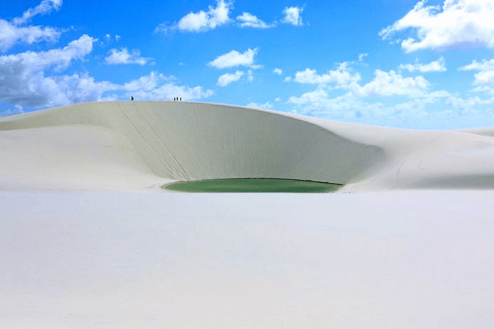
Thousands of lakes with different shapes and depths dot the desert, each reflecting a different color—deep blue, light green, or even reddish-brown when covered in algae. Locals give the lakes poetic names like Blue Lake, Love Lake, and Lake of Hope, reflecting their dreams and sentiments.
The most popular lakes, Blue Lake and Green Lake, are near Barreirinhas. Known locally as the “big sheet” and “small sheet,” Blue Lake is the largest, deepest, and most vibrant—and full of fish and crabs. Swimming here is not only refreshing but also offers a playful interaction with the aquatic life.
By day, the desert becomes a massive water park. You can pose for stunning photos, go on desert hikes, ride off-road jeeps with guides, or climb a dune and race down for thrills. You can even enjoy natural water slides and rafting in lake channels.
At peak water levels, adrenaline-seekers come here for kite surfing—an extreme sport powered by large kites that’s challenging but exhilarating. As dusk falls, the desert becomes a living oil painting.
Aerial Views and Jungle Adventures
For a different perspective, take a helicopter tour (about $130 USD per person) to see the lunar landscape of crescent dunes from the sky. It truly looks like linen sheets blowing in the wind.
Besides the lakes and dunes, you can explore nearby rainforests by boat, visit playful monkeys, climb lighthouses for panoramic views, or ride ATVs across the dunes, sip fresh coconuts, and savor uniquely flavored Brazilian grilled shrimp.
Final Thoughts
The Desert of a Thousand Lakes is a once-in-a-lifetime experience. During the rainy season, it transforms into an otherworldly wonder, where desert and water form a surreal harmony. But this miracle lasts only a few months each year—June and July are the best times to visit, as the lagoons are at their fullest before they begin to evaporate with the arrival of the dry season.
This desert defies logic and reshapes your understanding of the Earth. If you ever have the chance to go, don’t hesitate. It’s not just a journey—it’s a revelation.
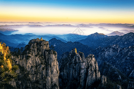
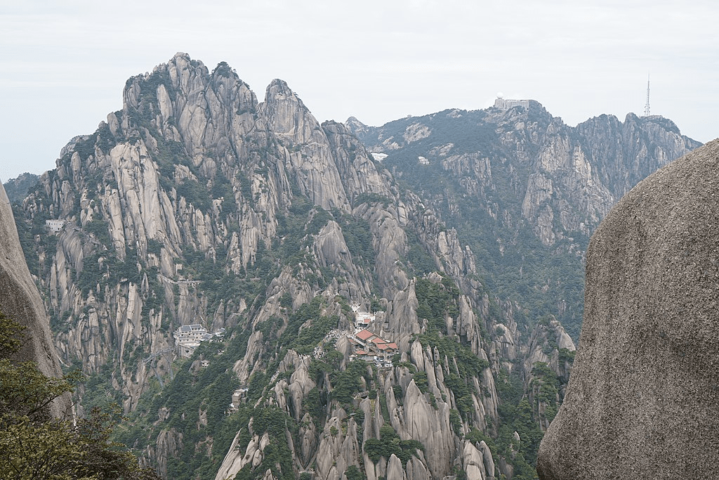
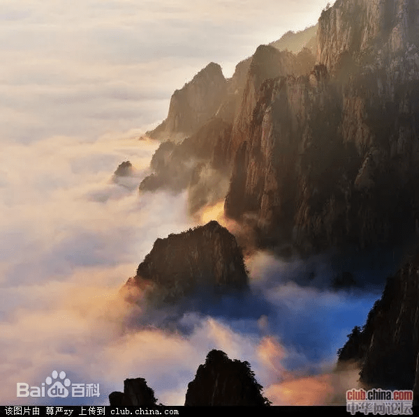
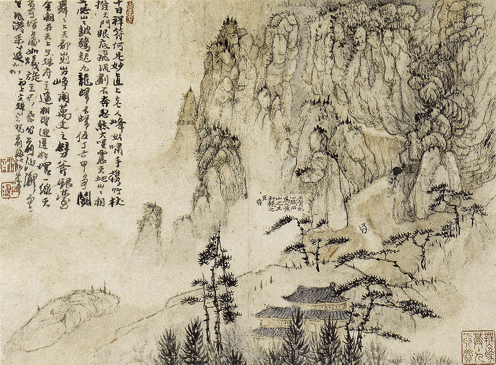
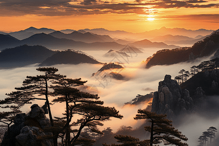
Mount Huangshan, often described as the “loveliest mountain of China,” has played a significant role in the history of Chinese art and literature since the Tang Dynasty around the 8th century. A legend from 747 AD recounts the discovery of the long-sought elixir of immortality on the mountain, which gave Mount Huangshan its name and cemented its place in Chinese history. This legend attracted hermits, poets, and landscape artists, drawn by the dramatic mountainous landscape featuring numerous granite peaks, many over 1,000 meters high, emerging through a perpetual sea of clouds. During the Ming Dynasty in the 16th century, the mountain’s unique rock formations and ancient gnarled trees inspired the influential Shanshui (“Mountain and Water”) school of landscape painting, which profoundly shaped the world’s perception of the oriental landscape.
Located in the humid subtropical monsoon climate zone of Anhui Province, Mount Huangshan covers an area of 16,060 hectares with a buffer zone of 49,000 hectares. It is noted for its botanical richness and the conservation of several locally or nationally endemic plant species, some threatened with extinction.
The cultural significance of Mount Huangshan’s scenic landscape was first recognized during the Tang Dynasty and has been revered ever since. Renamed Huangshan (Yellow Mountain) by imperial order in 747 AD, it became a popular destination for visitors who celebrated its inspiring scenery through painting and poetry, creating a rich body of art and literature of global importance. By the Yuan Dynasty (1271-1368), 64 temples had been constructed on the mountain. In 1606, the monk Pumen established the Fahai Meditation Temple. By the Ming Dynasty, Mount Huangshan had become a favorite theme of Chinese landscape painters, firmly establishing the Shanshui school of landscape painting. The interaction of man and nature in this scenic setting has inspired generations of Chinese artists and writers.
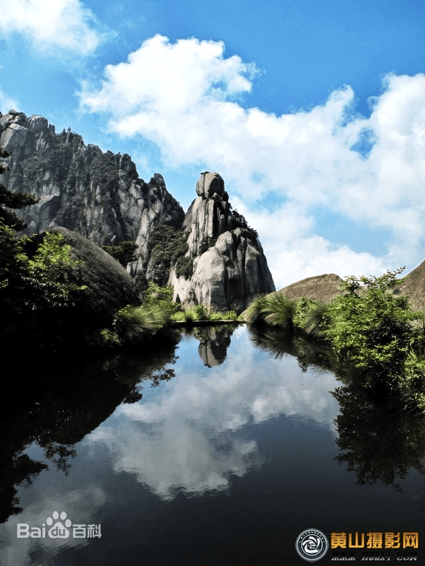
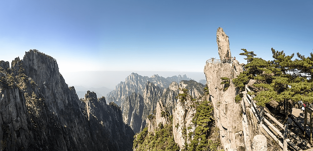
Mount Huangshan is renowned for its magnificent natural scenery, including massive granite boulders and ancient pine trees, often enhanced by cloud and mist effects. The dramatic landscape features natural stone pillars, grotesquely-shaped rocks, waterfalls, caves, lakes, and hot springs, formed by its complex geological history. The mountain range has many peaks, some over 1,000 meters high, with the three tallest and best-known being Lotus Peak (1,864 meters), Bright Peak (1,860 meters), and Celestial Peak (1,829 meters). The World Heritage Site covers a core area of 154 square kilometers and a buffer zone of 142 square kilometers. The mountains were formed in the Mesozoic era, approximately 100 million years ago, when an ancient sea disappeared due to uplift. Later, during the Quaternary Period, glaciers shaped the landscape.
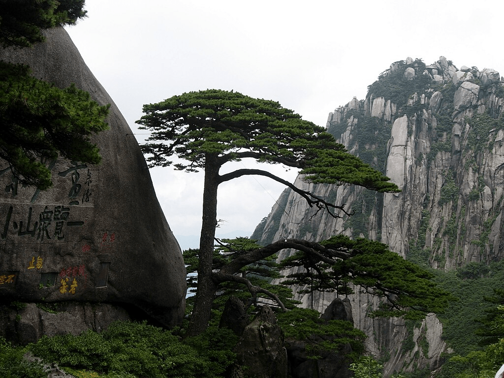
Vegetation varies with elevation, with mesic forests below 1,100 meters, deciduous forests up to the tree line at 1,800 meters, and alpine grasslands above that. The area boasts diverse flora, with one-third of China’s bryophyte families and more than half of its fern families represented. The Huangshan pine (Pinus hwangshanensis), named after the mountain, is a symbol of vigor as it thrives by growing straight out of the rocks. Many pine trees in the area are over a hundred years old and have unique names, such as the Welcoming-Guests Pine, thought to be over 1,500 years old. The pines vary greatly in shape and size, with the most crooked trees considered the most attractive. Huangshan’s moist climate also supports the growth of tea leaves, and the mountain is renowned as one of China’s premier green tea-growing areas. Mao feng cha (“Fur Peak Tea”), a famous local variety, takes its name from the downy tips of tea leaves found in the region.
Mount Huangshan often offers views of the clouds from above, known as the Sea of Clouds (yúnhǎi) or “Huangshan Sea,” due to their resemblance to an ocean. Many vistas are named after these cloud formations, such as “North Sea” or “South Sea.” A writer once remarked that to enjoy the magnificence of a mountain, you usually look upwards, but to enjoy Mount Huangshan, you must look downward. The area is also known for notable light effects, such as the renowned sunrises and the phenomenon called Buddha’s Light (fóguāng), which appears only a few times per month.
Mount Huangshan is famous for its stone steps carved into the mountain, with over 60,000 steps throughout the area. The origin date of these steps is unknown, but they are believed to be more than 1,500 years old. Over the years, many scenic spots and physical features have been named, often with narratives behind them. For example, one legend tells of a skeptic who, upon visiting the mountains, was immediately convinced of their beauty. One of the peaks he visited was named Shixin (始信), meaning “start to believe.”
Much of Huangshan’s reputation stems from its significance in Chinese arts and literature. It has inspired poets such as Li Bai, and has been a frequent subject of poetry, Chinese ink painting, and, more recently, photography. From the Tang Dynasty to the end of the Qing Dynasty, over 20,000 poems were written about Huangshan, and a school of painting was named after it. The mountains have also appeared in modern works; director James Cameron cited Huangshan as one of his influences in designing the fictional world of his 2009 film Avatar, and the Chinese animated series Stitch & Ai, a spin-off of Disney’s Lilo & Stitch franchise, is set in the Huangshan mountains.
In 1982, Mount Huangshan was declared a “site of scenic beauty and historic interest” by the State Council of China. It was designated a UNESCO World Heritage Site in 1990 for its scenery and as a habitat for rare and threatened species. Later, it was certified as a National Geopark and subsequently as a regional geopark (Asia Pacific Geopark Network), before being admitted as a UNESCO Global Geopark in 2004.
Mount Huangshan is a habitat for several locally or nationally endemic plant species, many of which are globally threatened. Its flora includes one-third of China’s bryophytes and over half of its pteridophytes. Endemic species to Huangshan include 13 species of pteridophytes and 6 species of higher plants, with many other species endemic to the region or China. This rich flora is complemented by a diverse vertebrate fauna of over 300 species, including 48 mammals, 170 birds, 38 reptiles, 20 amphibians, and 24 fish. Thirteen species are under state protection, including the Clouded Leopard (Neofelis nebulosa, VU) and the Oriental Stork (Ciconia boyciana, EN).
Additionally, Mount Huangshan has multiple hot springs, mainly located at the foot of Purple Cloud Peak. The water, maintaining a temperature of 42°C (107.6°F) year-round, is rich in carbonates and is said to help prevent skin, joint, and nerve illnesses.
The area has also been a site for scientific research due to its diverse flora and wildlife. In the early 20th century, both Chinese and foreign scientists studied the geology and vegetation of Huangshan. Research continues, such as a late 20th-century field study of Tibetan macaques, a local monkey species.
Nestled in the southeastern part of the Tibet Autonomous Region lies Mêdog, a town whose name translates to “hidden lotus” in Tibetan. Situated in the Nyingchi area, Mêdog finds its home in the lower reaches of the Yarlung Tsangpo River, nestled at the southern foothills of the eastern Himalayas. This picturesque town boasts breathtaking landscapes, abundant rainfall, and pristine ecology, making it a true hidden gem waiting to be explored.
Mêdog’s allure lies not only in its natural beauty but also in its remote location, which has preserved its untouched landscapes from excessive development and damage. With a relatively sparse population, Mêdog offers visitors a rare opportunity to experience unspoiled natural beauty and unravel the mysteries of nature.
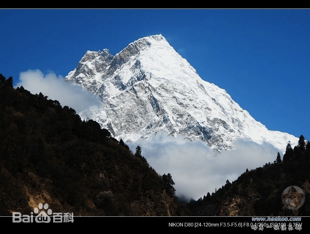
One of the most striking features of Mêdog is the majestic Yarlung Tsangpo River, which winds its way around the towering Namcha Barwa Peak, standing at an impressive 7,782 meters. As the river meanders through the territory of Mêdog, it carves a deep gorge akin to a sharp sword, creating a mesmerizing sight that resembles the Milky Way cascading towards the sea.
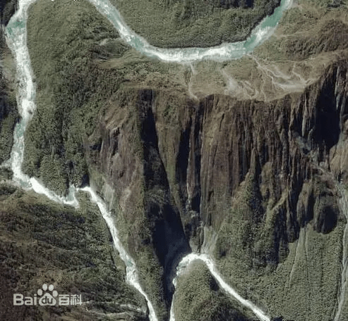
Big Bend
The Yarlung Tsangpo Grand Canyon stretches from Dado Kar village in Milin County at an elevation of 2880 meters in the north to Baxika village in Motuo County at an elevation of 115 meters in the south. The canyon spans a length of 504.6 kilometers, with an average depth of 2268 meters and a maximum depth reaching 6009 meters. With an average elevation of over 3000 meters, it holds the distinction of being the world’s largest canyon.
The entire canyon region is characterized by a harsh environment, where glaciers, cliffs, steep slopes, mudslides, and the turbulent Yarlung Tsangpo River converge. Many areas remain untouched by human activity, making it one of the few remaining “last frontiers” on Earth and a relatively unexplored geological blank spot.
Some of the primary waterfalls within the canyon have drop heights ranging from 30 to 50 meters. The canyon features nine vertical natural zones, ranging from high mountain snow zones to low river valley tropical rainforests. This diversity creates a habitat for a variety of biological resources, including two-thirds of known higher plant species on the Qinghai-Tibet Plateau, half of known mammal species, four-fifths of known insect species, and three-fifths of known large fungi species in China.
The convergence of warm and humid oceanic air currents with the snowy plateau gives rise to a unique climatic phenomenon in Mêdog. With annual rainfall reaching around 2000 millimeters and an average temperature of 16°C, Mêdog boasts rare South Asian climatic characteristics at its latitude. Despite its Tibetan location, Mêdog is home to the northernmost tropical rainforest in China, thriving with lush vegetation and vibrant landscapes reminiscent of Jiangnan’s greenery.
Exploring Mêdog offers visitors a chance to witness the breathtaking scenery of the Yarlung Tsangpo Grand Canyon, hailed as one of China’s ten most beautiful canyons by “National Geographic.” Here, travelers can marvel at the grandeur of nature while appreciating the unique rattan bridges that adorn the landscape, crafted without a single nail or pier.
As one traverses the mountains of Mêdog, they are greeted with mist-shrouded landscapes that change hues with the seasons, each unveiling its unique beauty. From the dense foliage to the meandering streams, Mêdog presents a captivating panorama that unfolds like a charming scroll, inviting visitors to immerse themselves in its vibrant colors and tranquil ambiance.
In the age of dinosaurs, a plant often referred to as a “living fossil” – the tree fern, also known as the “cycad,” is a nationally protected plant at the second level. It is the only woody fern species.
Wild Banana
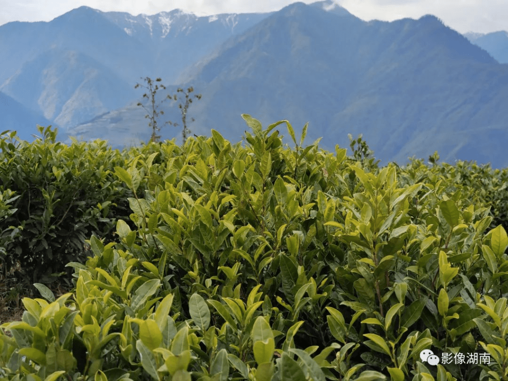
Tea Tree Farm
For those seeking respite from the hustle and bustle of city life, Mêdog offers a sanctuary of serenity and natural beauty. Whether it’s witnessing the grandeur of the Yarlung Tsangpo River or wandering through the lush rainforests, Mêdog promises an unforgettable journey filled with awe-inspiring moments and cherished memories.
In Mêdog, every step reveals a new wonder, every corner a hidden treasure. As visitors embark on this journey of exploration, they are reminded to approach nature with humility and appreciation, embracing its beauty with a calm heart and open mind. In Mêdog, the beauty of life reveals itself in every mist-covered peak and verdant valley, leaving an indelible mark on the soul of all who venture there.
Discovering the Hidden Gem of Tibet: Mêdog – Where Nature Unveils Its Mysteries